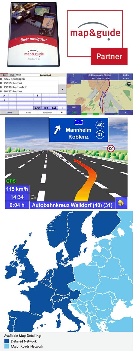
PTV FleetNavigator 10.5 (Europe incl. East-Europe, Speech, TMC) [PDA/PC]
[http://www.cartft.com/catalog/il/43]

  189.00 EUR
incl. 19% VAT, plus shipping

  • TMC support !
  • 2D/3D view !
  • Speech !
  • Map&Guide Fleet Navigator !
Support: API | Manual [DE] | Fact Sheet [DE] | Fact Sheet [EN] | Installation Guide [DE] | Installation Guide [EN] | Manual [EN]

Professional navigation on notebook, Car-PC or PDA with door-to-door routing and Touchscreen optimized interface. Audio navigation prompts are combined with a clear map display on the PC.

New in Version 10.5 (26.10.2018):
- Map data 2018.2N

New in Version 10.0 (21.11.2017):
- Bugfixes
- Map data 2017.2N

New in Version 9.0 (16.11.2015):
- Bugfixes
- Map data 2015.2N

New in Version 8.5 (16.10.2014):
- GLONASS-GPS-support
- Economic avoidance of toll for Germany and Austria
- Map data 2014.2N

New in Version 8.0 (25.11.2013):
- route planning with approximate stop-off points improved (fuzzy via)
- Map data 2013.2N

New in Version 7.5 (30.10.2012):
- due to the intelligent self- learning mode (ETA), time is calcula-ted on the basis of individual driving behaviour, resulting in a more accu-rate calculation of the time of arrival.
- route planning with approxi-mate stop-off points (fuzzy via)
- announcement of navigation instructions in off-road mode
- announcement of texts with Text2Speech
- display of other vehicles (bud-dies) with geofencing alerts
- only a few tags are sufficient to influence the routes.
- Map data 2012.2N

New in Version 7.0 (21.11.2011):
- Improved graphical design
- Option to "Avoid toll roads" [only PC/PDA]
- Self-learning vehicle profile [only PC/PDA]
- Faster address-search
- Map data 2011.2N

Basic functions
Mobile navigation is a popular alternative to an expensive installation. map&guide fleet navigator provides:

• Door-to-door cross-border navigation
• Intuitive, easy operation
• Precise visual cues and spoken instructions
• 2D and 3D navigation using map&guide clear, intuitive maps
• Proven, professional map&guide routing and navigation
• Extrapolated positioning in tunnels
• Dynamic navigation: The latest TMC information is received on a TMC receiver free of charge and used to update the route while on the road.
• map&guide fleet navigator supports the following languages: German, English, French, Dutch, Italian, Spanish, Portuguese, Danish, Norwegian, Swedish, Polish, Czech, Slovak, Slovenian, Hungarian, Romanian, Turkish, Russian, Bulgarian
• Auto-Smartzoom for optimum map information when approaching a manoeuvre
• Automatically switches between day and night view
• Speed warning limits also for trucks in many countries
• Text2Speech
• Coordinates input
• Global search for POIs
• Realistic motorway signs and junction views

Connected navigation
With map&guide fleet navigator it is possible to control the navigation of your service employees' cars from your control center: Order files (RC-Interface) and interfaces in C and C# (RI-Interface) enable communication between map&guide fleet navigator and a secondary software which establishes communication with the control center. These functions are used to:

• send stop-off points as address from the control centre to the navigation
• request GPS positions from the navigation and make them available to third-party applications
• start and end mobile navigation
• transfer and display messages to the navigation
• Guided navigation: Transfer of entire route navigation
• Show other vehicles (buddies) via interface

One fleet - various vehicle profiles
Create different vehicle profiles for the various vehicles in your fleet – this ensures that navigation is tailored to the vehicle. When creating vehicle profiles for cars and trucks with map&guide fleet navigator the following criteria can be taken into account:

• Speed profile
• Avoiding motorways or ferries
• For cars: Optimisation of route in terms of economy or time
• For trucks: Avoiding smaller streets (bypasses), turning, residential areas


Supported operating systems
• Microsoft Windows Mobile 2003 for Pocket PC (incl Second Edition)
• Microsoft Windows Mobile 5,6 (inkl. Phone-Edition)
• Microsoft Windows 2000, Windows XP, Windows Vista, Windows 7, Windows 8


Included maps :
- Maps of Europe (see Datasheet)


Scope of Supply :
- PTV FleetNavigator (includes PDA/PC program and all maps)


Screenshot-gallery with Step-by-Step introduction (Version 7)


Manuals
German
English
French
Dutch

Developer-API
Remote Control
Remote Interface